The Atlantic hurricane season is accelerating, with Tropical Storm Humberto on a track to become the season’s next major hurricane. However, the system currently designated as Invest 94L, which is forecast to become Tropical Storm Imelda, poses a more uncertain and potentially greater threat to the Bahamas and the Southeast U.S. coastline.
As of Friday, September 26, 2025, forecasters are tracking a complex scenario involving two powerful systems and the potential for a rare meteorological interaction that could dramatically change the forecast for millions.
Tropical Storm Humberto: Offshore but Rapidly Intensifying
Tropical Storm Humberto is currently located hundreds of miles east-northeast of the northern Leeward Islands, moving generally toward the northwest. It poses no immediate threat to the Caribbean.
Key Forecast Details:
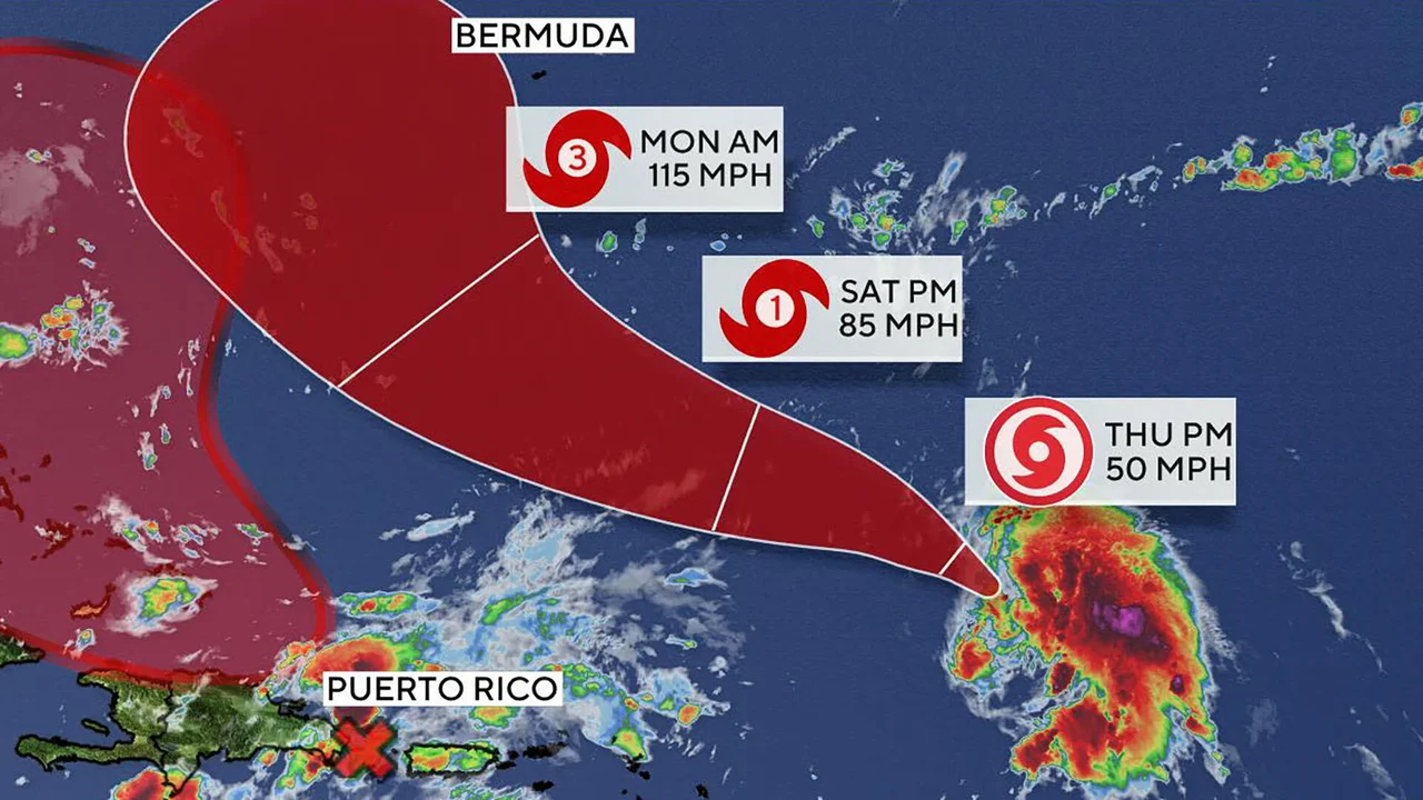
- Hurricane Status: Humberto is forecast to intensify into a Category 1 hurricane later today (Friday, September 26) and is expected to become a major hurricane (Category 3 or higher) by the weekend.
- Track: The consensus track keeps the storm curving out into the Central Atlantic, away from the U.S. East Coast, but it remains a possible threat to Bermuda early next week.
- Wider Impact: Even as it stays offshore, Humberto is large enough to generate significant swell that will contribute to dangerous rip currents and rough surf along the U.S. East Coast through the weekend.
Future ‘Imelda’ (Invest 94L) Poses Increasing U.S. Threat
The area of disorganized showers and thunderstorms known as Invest 94L is located near the Hispaniola and Turks and Caicos Islands. This system is forecast to develop into a tropical depression by late Friday and become Tropical Storm Imelda as it moves near the Bahamas this weekend.
The National Hurricane Center (NHC) gives Invest 94L a high chance of formation (90% over the next 7 days).
Impacts in the Caribbean:
Invest 94L is already bringing heavy rainfall and gusty winds to the Dominican Republic, Haiti, and the Turks and Caicos, with flooding and landslide risks. This heavy activity is expected to spread to eastern Cuba and the Bahamas over the weekend.
Long-Range U.S. Scenarios:
The forecast models show significant uncertainty for the U.S. next week, with two primary scenarios for Imelda after it passes the Bahamas:
- Direct Threat: Imelda continues moving northward and potentially tracks toward the coastlines of Georgia or the Carolinas as a tropical storm or hurricane early next week. Confidence in this scenario is currently increasing.
- Offshore/Absorbed: Imelda stalls briefly off the Southeast coast before being pulled eastward, away from the coast, or potentially being absorbed by the much larger Hurricane Humberto.
The NHC is urging all residents along the U.S. East Coast from Florida to North Carolina to closely monitor this system as the threat of wind, rainfall, and storm surge impacts is increasing.
The Complex ‘Fujiwhara Effect’ Wild Card
Adding to the forecast complexity is the possibility of the Fujiwhara effect, a phenomenon where two tropical cyclones (like the strengthening Humberto and developing Imelda) are close enough to begin orbiting around a common center.
- If this interaction occurs, the stronger system (Humberto) could absorb the weaker one (Imelda), essentially pulling the threat away from the coast.
- Alternatively, the systems could simply slingshot around each other, potentially causing an unpredictable wobble in Imelda’s track.
This possibility means the exact path and intensity of Tropical Storm Imelda will likely remain difficult to pinpoint until the system is fully organized and the interaction dynamics become clearer this weekend.
Coastal Threats: Beyond Landfall
Even if Imelda fails to make a direct landfall, both storms will generate widespread hazards along the entire Eastern Seaboard:
- Dangerous Rip Currents & Surf: Days of onshore winds from both Humberto and Imelda will generate high surf and life-threatening rip currents from Florida all the way to New England.
- Heavy Rainfall: Areas already dealing with recent rain and saturated ground, particularly in the Carolinas and Virginia, face an enhanced flash flood threat if Imelda’s rain bands move inland.
- Coastal Flooding: Minor coastal flooding due to high tides and storm swell is likely across the East Coast.
Action Recommended: Residents in the Bahamas and along the U.S. East Coast should finalize their hurricane preparedness plans and check local National Weather Service advisories frequently for the latest updates.
Related Posts

The Truth About the $1,390 Stimulus Check Rumors
The Truth About the $1,390 Stimulus Check Rumors Reports are…

Keanu Reeves: A Career in Film and a Legacy Beyond the Screen
Keanu Reeves: A Career in Film and a Legacy Beyond…

Tommy Fleetwood’s Long Wait Ends: First PGA Tour Win Secures FedEx Cup
Tommy Fleetwood's Long Wait Ends: First PGA Tour Win Secures…